Mohawk River Valley Region
Mohawk Valley Region's Path Through History
  • About
    • Region
    • Revolutionary War
  • My Path
  • Destinations
  • Bike Routes
  • Themed Itineraries
    • View All Itineriaries
    • Battlefields and Raids
    • Colonial Sites
    • Native Americans in the Revolution
    • Breadbasket of the Revolution
    • Footsteps of Washington
    • Trails to Roads
    • Western Frontier and the Border Wars
  • Events
  • News
  • Partners

Get your free brochure

Like us on Facebook Follow Us On Twitter Follow Us On Youtube Follow Us On Pintrest Follow Us On Instagram

Site Created by Brockett Creative Group, Inc.
Content Powered by tSpark CMS

Mohawk Valley Path Through History
BikeThruHistory.com
Download Our Brochure I ? NY - iloveny.com

Tour of Utica Sites

Previous Page

Utica/UticaMaennerchor/UticaCollege/OneidaHistoricalSociety

Oneida County
Length: 23 miles
Difficulty: EasyEasy

Directions

Beginning Point
at 0.00 mimiles
Start Point
at 0.01 mimiles
POI: Oneida County History Center
at 0.03 mimiles
Turn left onto Genesee St
at 0.60 mimiles
At the traffic circle, continue straight to stay on Genesee St
at 0.77 mimiles
POI: Munson-Williams-Proctor Arts Institute
at 1.03 mimiles
POI: The Stanley Theatre
at 1.30 mimiles
Sharp left onto Columbia St
at 1.85 mimiles
Turn left onto Huntington St
at 2.05 mimiles
POI: Saranac/F.X. Matt Brewery
at 2.06 mimiles
Turn right onto Court St
at 2.28 mimiles
Turn right onto Columbia St
at 2.57 mimiles
Turn left onto Cornelia St
at 2.71 mimiles
Continue onto Auditorium Dr
at 2.74 mimiles
POI: Utica Memorial Auditorium
at 2.77 mimiles
Turn right onto Whitesboro St
at 3.23 mimiles
Continue onto Broad St
at 3.32 mimiles
Turn left onto Railroad St
at 3.39 mimiles
Turn right onto Main St
at 3.39 mimiles
POI: Utica Children's Museum
at 3.41 mimiles
POI: Union Station
at 3.54 mimiles
Turn right onto 2nd St
at 3.59 mimiles
POI: Bagg's Square
at 3.60 mimiles
Turn left onto Broad St
at 4.58 mimiles
Turn right onto Milgate St
at 4.63 mimiles
Turn left onto Catherine St
at 4.99 mimiles
Continue onto Beechgrove Pl
at 5.29 mimiles
Turn right onto Florence St
at 5.35 mimiles
Turn left onto Bleecker St
at 5.59 mimiles
POI: Masonic Care Community
at 6.86 mimiles
Turn left onto Dyke Rd
at 8.04 mimiles
Continue onto Newport Rd
at 8.94 mimiles
Turn left onto Cosby Manor Rd
at 12.29 mimiles
Turn left onto Walker Rd
at 12.48 mimiles
Continue onto Coventry Ave
at 13.08 mimiles
Turn right onto New York State Bicycle Rte 5/Riverside Dr
at 14.70 mimiles
Turn right onto Sunrise Terrace
at 14.91 mimiles
Keep right to stay on Sunrise Terrace
at 14.91 mimiles
POI: Utica Maennerchor
at 15.16 mimiles
Turn right onto New York State Bicycle Rte 5/River Rd
at 17.16 mimiles
Turn left onto Cavanaugh Rd
at 17.46 mimiles
Continue onto Mohawk St
at 18.57 mimiles
Turn left onto Main St
at 19.06 mimiles
Continue onto Whitesboro St
at 20.11 mimiles
Turn right onto Champlin Ave
at 21.53 mimiles
Turn left onto Burrstone Rd
at 21.90 mimiles
Turn left toward Burrstone Rd
at 21.91 mimiles
Turn right onto Burrstone Rd
at 21.97 mimiles
Make a U-turn
at 22.31 mimiles
Turn left onto Lincoln Ave
at 22.45 mimiles
Turn right onto Newell St
at 22.67 mimiles
Turn left onto Sunset Ave
at 22.87 mimiles
Turn right onto Avery Pl
End Point
at 23.00 mimiles
End Point

Export Bike Route

View at RideWithGPS

Route Destinations

1

Bagg's Square

This area of downtown Utica features 19th century factory and warehouse buildings that once served the Erie Canal (now Oriskany Boulevard). Many have been repurposed for use as restaurants, specialty...

More Info
2

Masonic Care Community

The Masonic Care Community has been a vital part of Central New York for better than 116 years. In that time, thousands of men, women and children have benefited from our campus and its facilities.

More Info
3

Munson-Williams-Proctor Arts Institute

Museum of Art, Performing Arts, School of Art, Gift Gallery and Museum-admission free. Regional fine arts center

More Info
4
Old Fort Schuyler/Bagg's Tavern

Old Fort Schuyler/Bagg's Tavern

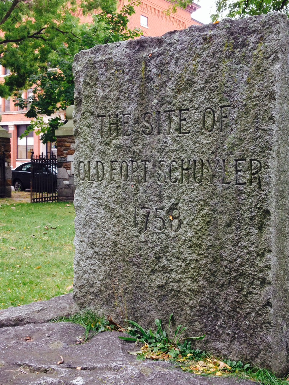
Old Fort Schuyler Marker and site of Bagg's Tavern: 1500 feet east of this spot was the great ford of the Mohawk, protected in 1758 by the erection of Old Fort Schuyler. Gen. Herkimer used this for...

  • 311 Main Street, Utica, NY
More Info
5

Oneida County History Center

Founded in 1876, the OCHS preserves and promotes the history of Oneida County and the greater Mohawk Valley through collecting and displaying artifacts, operating a research library, and hosting over ...

More Info
6

Saranac/F.X. Matt Brewery

Home of the Saranac line of beers and soft drinks, as well as Utica Club Pilsener. Brewery tours are available, describing the rich history of one of the United States' premier craft brewers. With ...

More Info
7

The Stanley

Originally built to be a movie palace, The Stanley opened on September 10, 1928 with 2,963 seats. In 1974 the Central New York Community Arts Council (a local nonprofit organization) acquired the prop...

More Info
8

Union Station

Utica's New York Central Station opened with great fanfare in May 1914. Necessary restoration began in 1978 and is ongoing.Now owned by Oneida County, the station serves Amtrak, Adirondack Scenic and ...

More Info
9

Utica Maennerchor

The Utica Maennerchor is one of the last surviving institutions established by a vibrant German immigrant community

More Info
10

Utica Memorial Auditorium

The 'Aud' is a multipurpose venue that hosts concerts, community events, and sporting events as diverse as ice hockey to gymastics. The building celebrated its 50th anniversary in 2010 and the follow...

More Info

Mar 21 - Jun 21

Declaration by Loyalists at Court in Johnstown

Join Our Mailing List

This field is required.

Recommended For You

Like us on Facebook Follow Us On Twitter Follow Us On Youtube Follow Us On Pintrest Follow Us On Instagram

Path Through History
I love NY

Site Map / Privacy Policy / Contact US

Site Created by Brockett Creative Group, Inc.

Content Powered by tSpark CMS